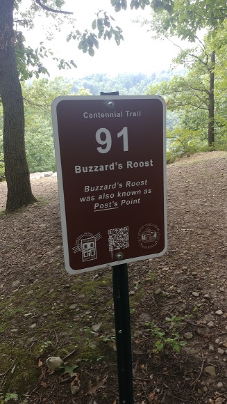
Upgraded – New metal markers on new posts – see pic below
What is the Tuscazoar Challenge?
The Camp Tuscazoar Foundation created a fantastic opportunity for Orienteering on the camp’s properties with some help from NEOOC.
From the Camp Tuscazoar – Centennial Trail webpage:
“As part of Camp Tuscazoar’s centennial celebration, a collection of 100 historic sites throughout camp have been identified and marked with a unique sign. Camp visitors are encouraged to hike to many or all of these sites to learn more about the camp’s rich history.”
In general, the Camp is open to the PUBLIC seven days a week, dawn to dusk, all year round. The markers are always up. Check the Camp Tuscazoar website for any Events or News that may be relevant to your visit. Also, we advise checking their Closure webpage before you visit.
The markers also encompass the area’s history including: the Ohio and Erie Canal, Native American lookouts, Dover Dam, three different mines: iron, coal, and bituminous coal, Zoarville Station, Zoar Valley Trail, and the Historic Zoar Village.
These 100 markers are spread all over the camp and includes every corner of the vast area. A fair number of the markers are located in the central camp area. So with this diverse distribution of markers, they can be used as a large area Score or Rogaine course or concentrated Sprint courses. Or both at once!
The map of the Centennial Trail is an 1 : 10000 scale Orienteering map and was created by NEOOC’s Bob Boltz.
Download the map and instruction booklet at the Camp Tuscazoar – Centennial Trail webpage. This map should be printed on 11×17 inch paper. Pre-printed maps and instruction booklet can by purchased at the Museum for a nominal fee (very limited hours). (Or see Ivan’s offer below about mailing them to you via USPS.) (See Bob’s tip below on how to prepare your map and the special Single Page Score Sheet .)
Alternately for the map, download and print these two files for 8.5 x 11 inch paper printouts:
Use portrait mode for these printouts. Note: there are reports that Control 22 might be found SE of Control 31.
YOU MUST SIGN IN AT THE KIOSK TO USE THE CAMP. The kiosk is located in front of the Stockade. This usage information is very important as the Foundation applies for grants to upkeep and improve the facilities on a regular basis.
TELL SOMEONE WHAT YOU ARE DOING AND WHEN YOU EXPECT TO RETURN. SAFETY FIRST! (see Sanae’s location sharing idea below)
Here is our thoughts on guidelines for this CHALLENGE:
- Do this as individuals or in groups, as part of your essential exercise program
- Use the Stockade area as the Start and Finish
- Find as many markers as you can in the time that you have planned for yourself. It can be one hour or five. Its’ up to you.
- Have fun and get some exercise. Do not over do it. Know your limits. Consult your Healthcare provider for guidance as needed.
- Time limit of 8 hours. Once the clock starts, it keeps going, no time off for breaks. Come back well before dark.
- Record the Key word from each marker found on the sheet below.
- Use this sheet to record the key words: Single Page Score Sheet (easier than the multi-page key word pages in the Booklet)
- At your option, you can email your GPS file as an attachment to: contact@neooc.com ——- RouteGadget is Up for this Event!
A Commemorative centennial coin is available for purchase ($5), see the details on the website. Note that this Challenge is separate from but complementary to the Camp Tuscazoar Foundation’s Centennial Trail program. You can do the Challenge and then come back later to find more markers. And your total can get you to the level needed for the coin purchase. (see Ivan’s note below).
Pack a lunch, snacks, and plenty of water. Make a day of it. Email questions to contact@neooc.com.
Cost
Zero! No charge!
However, consider one of the following to support the Camp:
- Put a small bill in the donation box near the Kiosk
- Become a Camp Tuscazoar Foundation member ($20) using this form. Deposit in the donation box (best put it in a small ziploc bag) OR send it in by mail.
Reporting your Personal Results
NEOOC has setup a webpage to self report your results:
Self-Reporting your Anytime Events Results
This is completely on the honor system. Have fun!
Your results will be added to the Results list below once we have transferred the information properly. It may take a little while.
Seeing the Overall Results – Attackpoint event
Tuscazoar Challenge Ongoing Results
Join the discussion at Attackpoint!
Caveats
Before you go, check the Camp’s homepage for any updates about restrictions on camp usage or construction issues:
ALSO, with the spring rain patterns, up to 7 marker could be under water or unreachable. For instance, the pool elevation at Dover Dam reached 882 at one point in March 2020, which is 12 feet higher than normal. The Tuscarawas River islands have max elevations of 878. Bob Boltz found that 5 controls (including the Zoarville Station Bridge) were unreachable at that time back in March 2020.
Anything above 875 feet causes trouble. Use this link to find the current water level information Water Management – Huntington District – U.S. Army Corps of Engineers (See Dover Dam, Current Pool Tab, Lake Elevation value).
Location
Notes, Tips, Photos, etc.
Ivan Redinger’s Offer – Getting the material in the mail via USPS:
I will mail the Guide and Map, and their Coin when the time is appropriate (for those who reach the Brave, Warrior or Chief level), if they send me a check made payable to “Camp Tuscazoar Foundation” for $10, (No S & H charges!)
Ivan Redinger
Camp T CC
116 Cleveland Ave. NW, Suite 418
Canton, Ohio 44702
Also, just the coin can be purchased from Ivan for $5. Send a copy of your key words list as proof of completion ( > 50).
Bob Boltz’s tip for preparing for the Challenge:
I wanted to minimize any problems I would have with protecting the map and answer form. The attached pic shows the front and back view of my setup. They have been laminated with a little clear film left around the edges in case I encounter water, sweat, etc. I found that an Ultrafine Permanant Sharpie works perfect and seems to dry instantly and not smear. Having this ready before you start will make your day lots more pleasant. I’m taking a spare pen just in case.

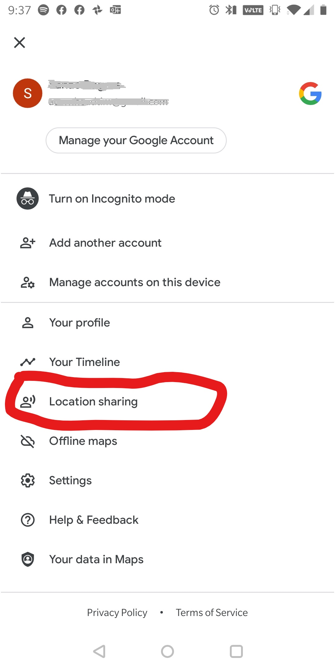
Sanae’s location sharing idea:
I found neat function in Google Map. It’s called “location sharing”. You can turn the function on with your family or friend and let them know you will be in the woods and approx. how long, or by when you will be back.
If something happens on you, they will know your location and call rescue or come find you ☺
 New Updated Upgraded Metal markers: