Categories
Course Design Gear Mapping

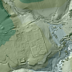
Mapping: 3D Laser Scans of Britain Reveal Ancient Roman Roads

For the past 18 years, the U.K.’s Environment Agency has used a remote sensing methodcalled LIDAR (short for Light Detection and Ranging) to scan and map 72 percent of England’s surface. The 3D terrain images are used to monitor changing coastlines and model floods. But the maps recently revealed something else: an exciting archaeological find. Within the images, experts spotted miles upon miles of ancient Roman roads that may date back as far as the first century CE. Click to read more…
Categories
Gear Orienteering Training

It’s cold outside! 5 Tips for How to Stay Warm

Winter has finally joined us, with a frigid -2F / -19C today (14 FEB 2016), to celebrate a frosty Valentine’s Day in Ohio. Here are science-based 5 tips for how to keep warm while enjoying the outdoors, whether that’s running, orienteering, hiking, or just playing in the snow!

Categories
Gear Orienteering Training

Get Your Own SPORTident Stick

If you’ve been around orienteering or a while, you’ve probably seen the e-punch system we use to collect electronic timing for runners on various courses. Here’s more about them, and how to get your own.