Results from the Pine Hollow Short XC event on April 2, 2017.

Results from the Pine Hollow Short XC event on April 2, 2017.

If you’re looking for a new adventure, a lifetime sport that will take you, literally, off the beaten path, constantly challenge you, and let you discover new things about yourself and what you can do, orienteering may be the sport for you. $5 event fee.

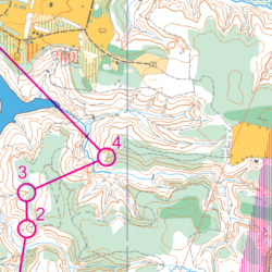
Join us for short and intermediate courses in the Kendall Lake area. We start at Pine Hollow, off of Quick Road for a new start / finish location. Bring your running shoes (with cleats, perhaps!), and get ready to stretch those legs!
Thanks for attending today’s Course Design Clinic with Bob Boltz. Here are some of the resources we worked with, along with sample map files, control descriptions, etc.

Angus was an incorporating member of NEOOC and helped draft the club’s very first
map, which was at Hell Hollow in the Lake Metroparks.

Wow! What an event, and what a turnout! With 41 timed individuals or groups out and about in the woods, it was a busy morning registering and starting runners at NEOOC’s first event of the year. Sure, we had “planned” for snow, and some colder temperatures. Ice cream sandwiches (and maybe the use of snow shoes) were promised, but neither happened! We had temps in the mid-40s instead, overcast, with wet and muddy ground conditions. In other words, a perfect day for orienteering!
Join NEOOC’s mapping guru Bob Boltz and a few others to learn more about course design, and what it takes to prepare great, but appropriately challenging, maps for all participants – from beginner to advanced orienteers. Topics will include basic design principles, designing for the beginner and advanced orienteer, and how to check your design for trouble areas. You’ll learn how to use Purple Pen, a course design software, as part of the workshop.

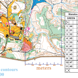
Join us for a potentially snowy and cold first event of the year at Camp Manatoc. Well feature WHITE and YELLOW (beginner) courses, and GREEN and RED (advanced) courses. The beginner courses will stay near campus, whereas the advanced courses will travel up and around one of the lakes. Beautiful views are guaranteed, and you’ll be sure to stay warm from the typical terrain in Cuyahoga Valley, with lots of up and down, mixed with flatter sections to stretch the legs on.

Help us make it a great 2017 for NEOOC by volunteering some of your time running an event.
Most of the jobs are easy to learn, and there are plenty who would love to show you how.

Our compasses aren’t surveyors’ tools – any bearing you measure on the map will likely be off by one or two degrees. As you follow the bearing, you are likely to unconsciously veer off another degree or two. Sometimes these errors will offset each other and you’ll end up exactly on target. But at other times they will compound each other. Over a 100 meter leg, a 3 degree error will put you 5 meters off course. You will likely still be able to see your target. But over a 500 meter leg, the same error would put you over 25 meters off course. You might very well not be able to see the control. So use your compass wisely as you apply the Five Key Skills: Use it to orient your map, and use it to aim yourself in a general direction, but when you use it to try to pick a precise line to a specific point, keep the distance as short as possible.