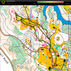
Andreas Johansson from NEOOC describes how to overlay your GPS track (from a Garmin device) on a map, and how to adjust the track.
Category: Training
We were just getting started with 30 pre-registered scouts, when 12 more showed up to learn about orienteering! A few more tables and chairs later, and we were all learning about the basics of orienteering. Some of the requirements for the Boy Scout Merit Badge for orienteering were covered, and scouts practiced taking compass bearings, taking their pace count, and about land forms, orienteering map features, and some of the basic techniques an orienteer uses while on a course. Click to read more…
O-Skills: Using Handrails
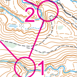
Using handrails is an easy way to get from one control to the next. A handrail is a feature you can easily follow out in the woods, like a trail, water feature, distinct contour line (like running along a ridge line), or something similar. In the example below, the trail acts as the handrail from control 1 to control 2.
Winter has finally joined us, with a frigid -2F / -19C today (14 FEB 2016), to celebrate a frosty Valentine’s Day in Ohio. Here are science-based 5 tips for how to keep warm while enjoying the outdoors, whether that’s running, orienteering, hiking, or just playing in the snow!
Looking for a challenging and fun outdoor activity? Try Orienteering! Join Stark Parks for an introduction to this family of sports requiring the use of a map and compass to navigate from point to point through a variety of diverse and unfamiliar terrains. We’ll cover navigational techniques, orienteering lingo, and introduce you to ways in which you can participate in this fun, family friendly activity.
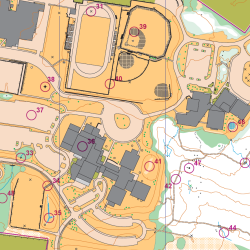
Join us to learn more about the sport of orienteering, and learn how to use a map and compass to navigate around the campus, while getting some exercise. We’ll provide instruction and guidance, and have all levels of courses available, from white to red. Map Included / compass for loan. NOTE!!! Don’t need instruction? No worries – come run the sprint courses on this beautiful campus, where plenty of challenges await even the most experienced orienteer!
Orienteering mapping and course design clinic that will focus on both theory and application of course design, the practical and technical aspects of designing courses using software, and setting courses. For experienced orienteers only. Bring your own laptop if desired, but workshop will start in a computer lab with the software already loaded. Click on the post for more information, and to register. Registration required!
Video / Micro-Orienteering
We talked about micro-O the other day, and here’s a great example from a Swedish gym hall (gympasal).
Part 2 of the map reading tutorial by the Irish Orienteering Association.
Part 1 of a simple map reading tutorial by the Irish Orienteering Association.