Categories
Course Design Gear Mapping

Mapping: 3D Laser Scans of Britain Reveal Ancient Roman Roads

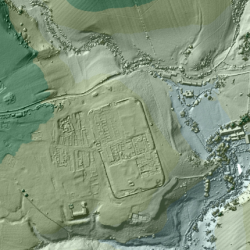
For the past 18 years, the U.K.’s Environment Agency has used a remote sensing methodcalled LIDAR (short for Light Detection and Ranging) to scan and map 72 percent of England’s surface. The 3D terrain images are used to monitor changing coastlines and model floods. But the maps recently revealed something else: an exciting archaeological find. Within the images, experts spotted miles upon miles of ancient Roman roads that may date back as far as the first century CE. Click to read more…

Categories
Events Orienteering Training Workshops

NEOOC Course Design Clinic / 27 FEB 2016

Orienteering mapping and course design clinic that will focus on both theory and application of course design, the practical and technical aspects of designing courses using software, and setting courses. For experienced orienteers only. Bring your own laptop if desired, but workshop will start in a computer lab with the software already loaded. Click on the post for more information, and to register. Registration required!

Categories
Orienteering Training

Mapping Resources for Orienteering

There are lots of great tools for orienteering, and mappers interested in creating their own maps. We have put together a small sample of the tool we use in the club for creating maps, setting up events, and so on. Our favorites are probably OCAD (the industry standard) and Purple Pen (for route setting), and many of the club members track their runs using GPS, and then some sort of analysis tool. Visit our Mapping Resources page for more.